Trimble R2 GNSS Receiver
Up for sale is an excellent Trimble R2 GNSS Receiver. This R2 has CM Accuracy with every option enabled. It also has the internal UHF Antenna enabled to be a rover
Condition: Used
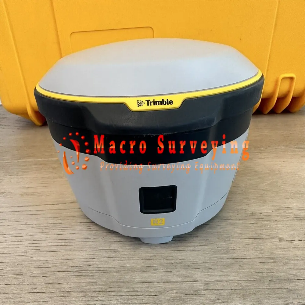
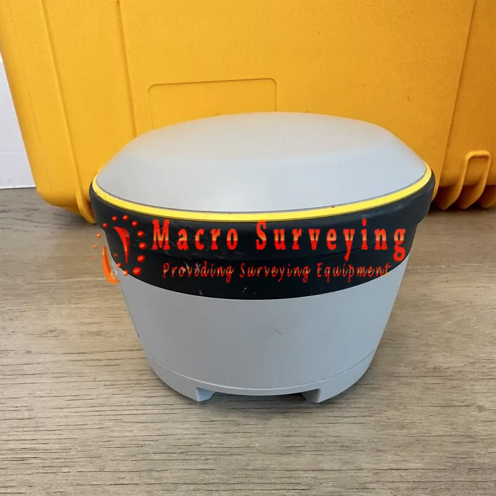
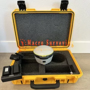


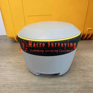
Up for sale is an excellent Trimble R2 GNSS Receiver. This R2 has CM Accuracy with every option enabled. It also has the internal UHF Antenna enabled to be a rover. 403 - 473MHz Frequency Range. Dual Frequency GPS, GLONASS, BeiDou, Galileo, QZSS, Max Precision and Radio are all enabled perpetually. Capable of VRS and RTX Corrections and with it's 220 channels.
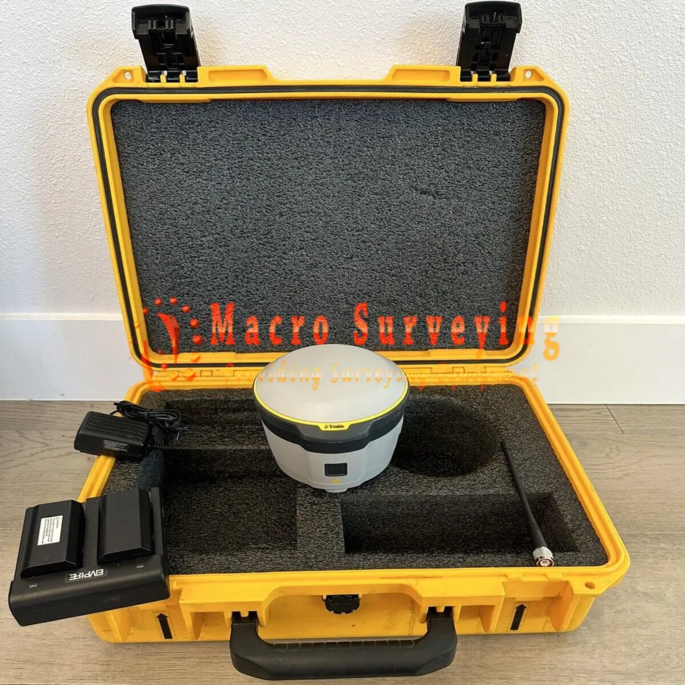
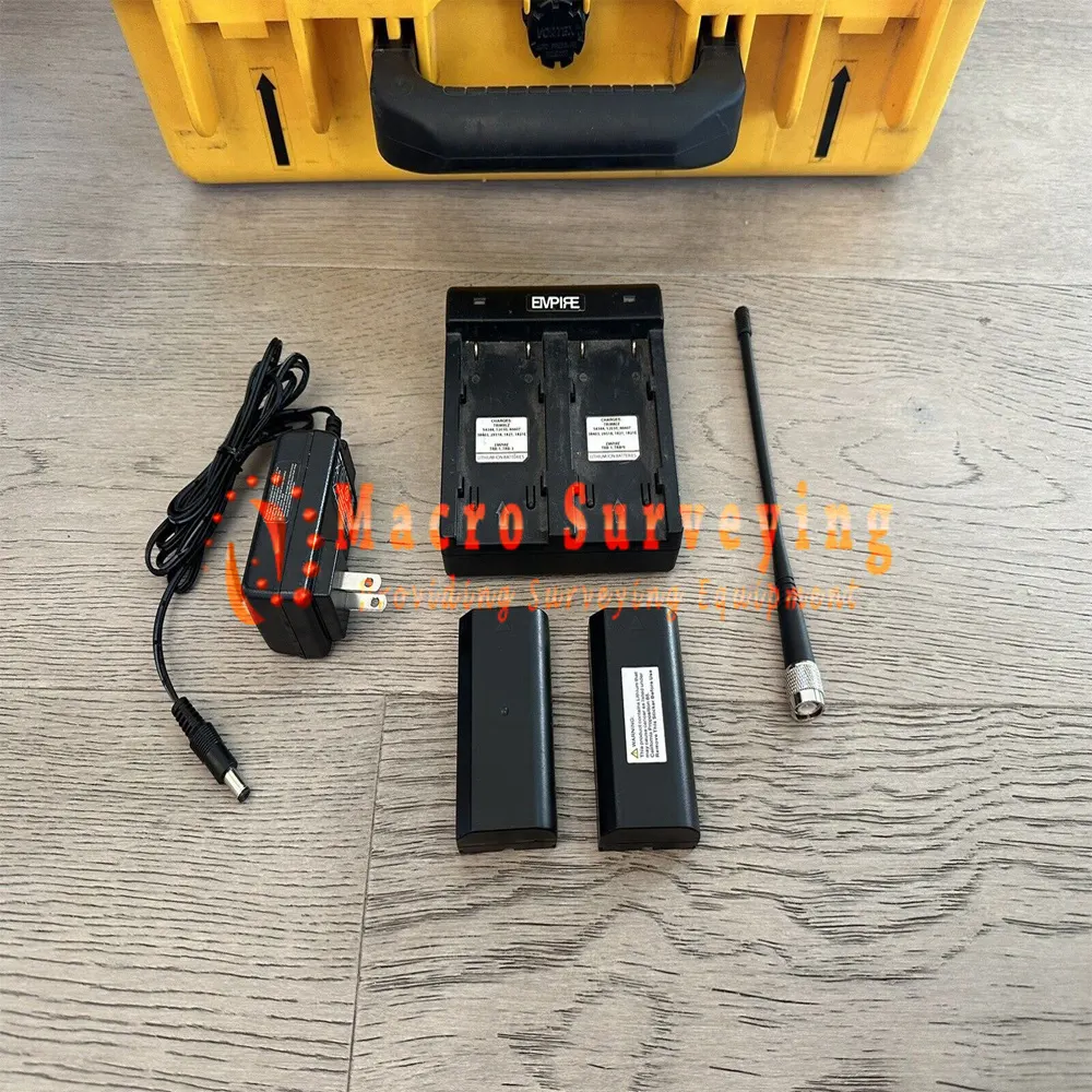
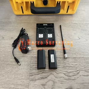
Sell used Trimble R2 GNSS Receiver includes:
- Trimble R2 GNSS Receiver
- 2 X R2 batteries
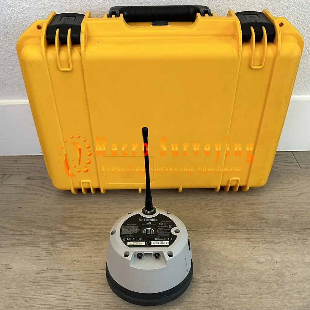
- UHF Antenna
- Dual Battery Charger
- Power Supply for dual charger
- Yellow Rugged Transport Case
The Trimble R2 is a compact, durable GNSS receiver that provides an easy-to-use solution for GIS and survey professionals who need to collect highly accurate data in a wide range of geospatial applications. Capable of delivering between submeter and centimeter positioning accuracy in real-time to any mobile device via a wireless Bluetooth® connection, the R2 receiver gives you total flexibility to choose a solution based on the accuracy and GNSS performance level that suits your application, letting you work the way you want.
- A professional solution for geospatial applications ranging from sub-meter to centimeter accuracies to support any GIS or survey-grade workflow
- Easily collect data by pairing with devices such as smartphones, tablets or Trimble handhelds using Trimble Survey and GIS software
- Fast to setup, easy to use, keeping you productive and focused at your task at hand
- Supports multiple satellite constellations and correction sources for accurate data at any location
- Compact, cable-free design with integrated antenna
High accuracy for survey & GIS applications
- Capable of delivering submeter to centimeter level positioning accuracy in real-time to suit any field data collection application.
- Achieve higher accuracy in real-time using correction sources from SBAS and VRS networks to Trimble RTX™correction services, delivered by either satellite or Internet, or via traditional RTK methods.
- Supports multiple satellite constellations and augmentation systems to provide maximum accuracy and positioning performance.
Flexible solution
- Able to be paired with any mobile device on a variety of operating systems and platforms, from a Trimble handheld or controller to a modern smartphone or tablet.
- You can select the accuracy and GNSS performance level appropriate for your application.
- Capable of being operated either mounted on a pole, on a backpack or on a vehicle.
- Integrates with Trimble software such as Trimble Access™, Trimble TerraFlex™ and Trimble Business Center to enable data to be easily collected, communicated and processed, providing you with high-quality deliverables for your organization.
Simple, rugged system
- Built to withstand the rigors in the field, the rugged IP65-rated Trimble R2 receiver will work as hard as you do in tough outdoor conditions.
- One-button start up and compact, streamlined form factor makes it fast to set up and can be operated either mounted on a pole, on a backpack or on a vehicle.
- The field-swappable battery means all day productivity with no interruptions, keeping you focused on the job at hand.
Trimble R2 GNSS RECEIVER Spesification
| CONFIGURATION OPTION | |
| Type | Smart antenna |
| Base operation | Yes. Logging only |
| Rover operation | Yes |
| Rover position update rate | 1 Hz, 2 Hz, 5 Hz |
| Rover operation within a VRS Now™ network | Yes |
| MEASUREMENTS |
|
| POSITIONING PERFORMANCE | |
| SBAS (WAAS/EGNOS/MSAS/GAGAN) Positioning |
|
| Code Differential GPS Positioning |
|
| Static GNSS Positioning | Static and Fast Static
|
| Post-Processed Kinematic2 Centimeter / Decimeter Configurations |
|
| Post-Processed Kinematic Sub-meter Configurations |
|
| Trimble RTX Positioning |
|
| RTK Positioning |
|
| Network RTK |
|
| INTERNAL ANTENNA | |
| Frequency Range | L1/L2 (GPS, GLONASS, Galileo, BeiDou, QZSS), MSS (RTX), L1 SBAS |
| COMMUNICATIONS | |
| USB | 1 USB 2.0 (Type B) device |
| Wi-Fi | Simultaneous client and access point (AP) modes |
| Bluetooth wireless technology | Fully-integrated, fully-sealed 2.4 GHz Bluetooth module |
| Network protocols | HTTP (web browser GUI); NTP Server, TCP/IP or UDP; NTRIP v1 and v2, Client mode; mDNS/uPnP service discovery; dynamic DNS; eMail alerts; network link to Google Earth; PPP and PPPoE |
| Supported data formats |
|
| External GSM/GPRS modem, cell phone support |
|
| CERTIFICATIONS |
|
| ENVIRONMENTAL | |
| Temperature |
|
| Humidity | 100% condensing |
| Waterproof | IP65 |
| Pole drop | Designed to survive a 2 m (6.6 ft) drop onto all faces and corners onto concrete (25C) |
| Shock |
|
| Vibration | MIL-STD-810G (Operating), Method 514.6, Procedure I, Category 4, Figure 514.6C-1 (Common Carrier, US Highway Truck Vibration Exposure) Total Grms levels applied are 1.95 g |
| BATTERY AND POWER | |
| Internal | Rechargeable, removable Lithium-ion battery in internal battery compartment |
| External | Power input on the Mini-B USB connector, non-charging as per the USB standard 10 W USB adapter |
| Power consumption | 4.95 W (VFD 100%), 3.7 W (VFD 12.5%) at 18 V, in rover mode Operation time on internal battery |
| Rover | 5 hours; varies with temperature |
| MECHANICAL | |
| User interface | LED indicators for receiver status On/Off key for one-button startup |
| Dimensions (Diameter x Height) | 14.0 x 11.4 cm (5.5 x 4.5 in.) |
| Weight | 1.08 kg (2.38 lb) receiver only |