Trimble R10 GNSS GPS Base Rover Receiver Kit
Selling used Trimble Dual R10 GNSS GPS 450-470 MHz UHF Base & Rover Receiver Kit.
Condition: Used

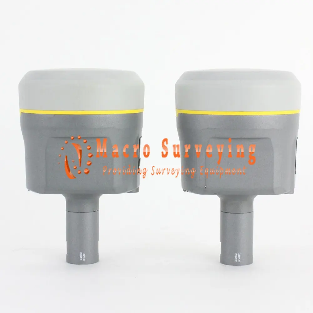
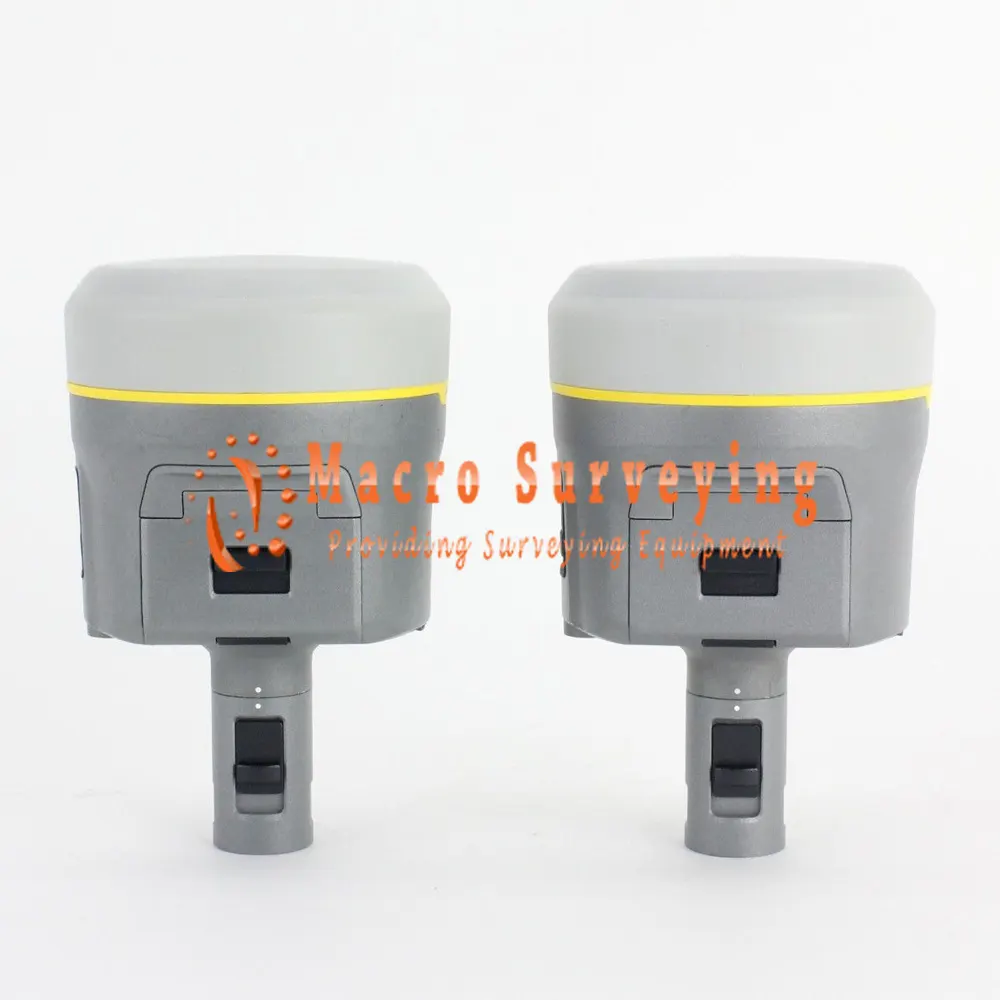
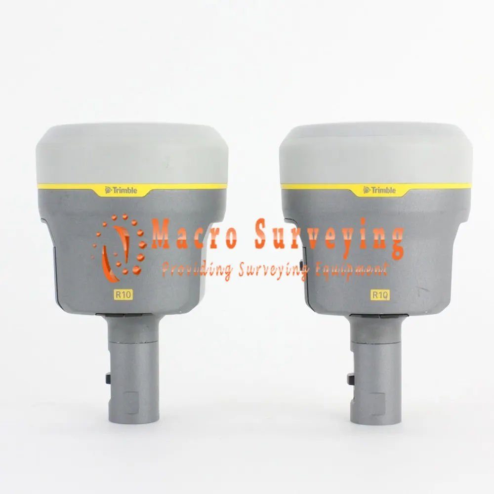
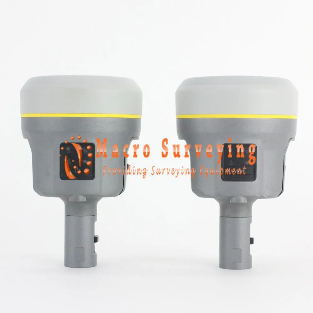
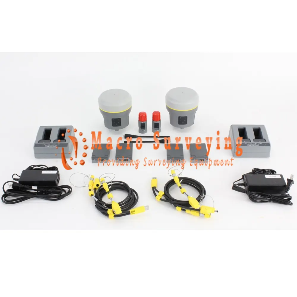
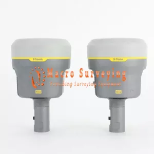
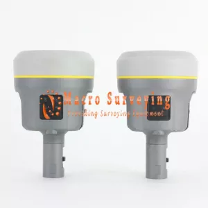
Up for sale Dual Trimble R10 GNSS Base Rover Receiver Kit. This is all in good used condition with minor wear (See Pictures) We offer a 90 days warranty and 30 days money back guarantee.
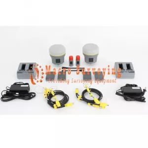
Package Includes:
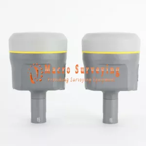
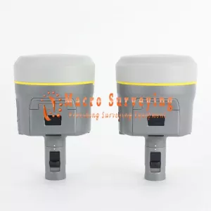
- Trimble R10 Base Receiver
450-470 MHz Internal Rx/Tx Radio (403-473 MHz Option)
L2, L2C, L5, GLONASS, Galileo, QZSS, & BeiDou Sats Enabled- 1X Trimble Dual Battery Charger
- 2X Lithium Ion Batteries
- 1X Radio Antenna
- 1X Quick Disconnect Adapter
- 1X USB Data Cable
- 1X Seco 0.25m Extension Rod
- 1X 12V Power Cable w/ Alligator Clips
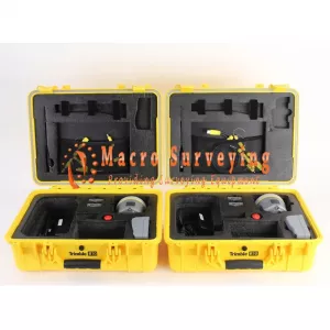
- 1 X Trimble Transport Case
- Trimble R10 Rover Receiver
450-470 MHz Internal Rx/Tx Radio (403-473 MHz Option)
L2, L2C, L5, GLONASS, Galileo, QZSS, & BeiDou Sats Enabled- 1X Trimble Dual Battery Charger
- 2X Lithium Ion Batteries
- 1X Radio Antenna
- 1X Quick Disconnect Adapter
- 1 X USB Data Cable
- 1X Trimble Transport Case
- 90 Day warranty
- 30 Day return
Current Enabled Options:
- eBubble Electronic Bubble
- xFill
- L2CS
- UHF Transmit
- Cellular
- L5
- LBand
- GLONASS
- Transmit High Power
- BeiDou
- Galileo
- Max Data Rate: 20 Hz
PURE, UNINTERRUPTED SURVEYING
Collect more accurate data faster and easier, no matter what the job or the environment, with the Trimble® R10 GNSS system.
Trimble 360 Receiver
Powerful Trimble 360 receiver technology in the Trimble R10 supports signals from all existing and planned GNSS constellations and augmentation systems. With the latest and most advanced Trimble GNSS technology, the Trimble R10 offers an unparalleled 672 GNSS channels to future-proof your investment.
The new Trimble R10 also provides improved interference protection to suppress a variety of intentional and unintentional sources of interference, as well as spoofing, for optimal performance in today’s increasingly crowded signal frequency spectrum.
Trimble HD-GNSS Processing Engine
The advanced Trimble HD-GNSS processing engine provides markedly reduced convergence times as well as high position and precision reliability while reducing measurement occupation time. Transcending traditional fixed/float techniques, it provides a more accurate assessment of error estimates than traditional GNSS technology.
Trimble SurePoint
With Trimble SurePoint™ technology, an electronic level bubble is displayed on the Trimble controller screen, allowing surveyors to maintain focus where it matters most. Full tilt compensation allows the survey pole to be tilted up to 15° when measuring, allowing the Trimble R10 to capture points that would be inaccessible to other GNSS surveying systems.
Trimble CenterPoint RTX
Trimble CenterPoint® RTX delivers RTK level precision anywhere in the world without the use of a local base station or VRS™ network. Survey using satellite or internet delivered CenterPoint RTX correction services in areas where terrestrial based corrections are not available.
Trimble xFill
Leveraging a worldwide network of Trimble GNSS reference stations and satellite datalinks, Trimble xFill® technology seamlessly fills in for gaps in your RTK or VRS correction stream. Maintain centimeter-level accuracy beyond 5 minutes with a CenterPoint RTX subscription.
Smart, Versatile
The Trimble R10 is a versatile solution, loaded with smart features to support any workflow, all day long:
- Integrated cellular modem to receive VRS corrections or operate as a mobile hotspot
- Wi-Fi to connect to a laptop or smartphone to configure the receiver without a Trimble controller
- Bluetooth to connect to an Android or iOS mobile device running supported apps
- 6 GB internal memory to store raw observations
- Smart lithium-ion battery, with built-in battery status indicator
- Improved power management increases battery life and operating time in the field on average by 33%
Key Features:
- Advanced satellite tracking with Trimble 360 receiver technology and latest generation Trimble Custom Survey GNSS ASIC with 672 GNSS channels
- Improved protection against sources of interference and spoofed signals
- Support for Android and iOS platforms
- Cutting-edge Trimble HD-GNSS processing engine
- Precise position capture and full tilt compensation with Trimble SurePoint technology
- Trimble CenterPoint RTX provides RTK level precision worldwide without the need for a base station or VRS network
- Trimble xFill technology provides centimeter-level positioning during connection outages
- Sleek ergonomic design for easier handling
Trimble R10 Specifications
|
PERFORMANCE SPECIFICATIONS |
||||||||
| MEASUREMENTS | ||||||||
| Measuring points sooner and faster with Trimble HD-GNSS technology | ||||||||
| Increased measurement productivity and traceability with Trimble SurePoint electronic level bubble and tilt compensation | ||||||||
| Worldwide centimeter-level positioning using Trimble CenterPoint RTX satellite or internet delivered correction services | ||||||||
| Reduced downtime due to loss of radio signal or cellular connectivity with Trimble xFill technology | ||||||||
| Advanced Trimble Custom Survey GNSS chips with 672 channels | ||||||||
| Future-proof your investment with Trimble 360 GNSS tracking | ||||||||
|
||||||||
| CenterPoint RTX, OmniSTAR® HP, XP, G2, VBS correction services WAAS, EGNOS, GAGAN, MSAS | ||||||||
| Reliable tracking in challenging environments with advanced Low Noise Amplifier (LNA) with 50 dB signal gain to reduce signal tracking effects caused by high power out-of-band transmitters |
||||||||
| Additional iridium filtering above 1616 MHz allows antenna to be used as close as 20 m of iridium transmitter | ||||||||
| Additional Japanese filtering below 1510 MHz allows antenna to be used as close as 100 m of Japanese LTE cell tower | ||||||||
| Digital Signal Processor (DSP) techniques to detect and recover from spoofed GNSS signals | ||||||||
| Advanced Receiver Autonomous Integrity Monitoring (RAIM) algorithm to detect and reject problem satellite measurements to improve position quality |
||||||||
| Improved protection from erroneous ephemeris data | ||||||||
| Positioning Rates 1 Hz, 2 Hz, 5 Hz, 10 Hz, and 20 Hz | ||||||||
|
POSITIONING PERFORMANCE |
||||||||
| Code Differential GNSS Positioning | ||||||||
| Horizontal | 0.25 m + 1 ppm RMS | |||||||
| Vertical | 0.50 m + 1 ppm RMS | |||||||
| SBAS differential positioning accuracy | typically <5 m 3DRMS | |||||||
| Static GNSS Surveying | ||||||||
| High-Precision Static | Horizontal: 3 mm + 0.1 ppm RMS | |||||||
| Vertical: 3.5 mm + 0.4 ppm RMS | ||||||||
| Static and Fast Static | Horizontal: 3 mm + 0.5 ppm RMS | |||||||
| Vertical: 5 mm + 0.5 ppm RMS | ||||||||
| Real Time Kinematic Surveying | ||||||||
| Single Baseline <30 km | Horizontal: 8 mm + 1 ppm RMS | |||||||
| Vertical: 15 mm + 1 ppm RMS | ||||||||
| Network RTK | Horizontal 8 mm + 0.5 ppm RMS | |||||||
| Vertical 15 mm + 0.5 ppm RMS | ||||||||
| RTK start-up time for specified precisions | 2 to 8 seconds | |||||||
|
TRIMBLE RTX™ TECHNOLOGY (SATELLITE AND CELLULAR/INTERNET (IP)) |
||||||||
| CenterPoint RTX | Horizontal: 2 cm RMS | |||||||
| Vertical: 5 cm RMS | ||||||||
| RTX convergence time for specified precisions Worldwide: < 3 min | ||||||||
| RTX QuickStart convergence time for specified precisions: < 5 min | ||||||||
| RTX convergence time for specified precisions in select regions (Trimble RTX Fast Regions): < 1 min | ||||||||
|
TRIMBLE xFILL |
||||||||
| Horizontal | RTK + 10 mm/minute RMS | |||||||
| Vertical | RTK + 20 mm/minute RMS | |||||||
|
HARDWARE |
||||||||
| Phisycal | ||||||||
| Dimensions (W x H) | 11.9 cm x 13.6 cm (4.6 in x 5.4 in) | |||||||
| Weight | 1.12 kg (2.49 lb) with internal battery, internal radio with UHF antenna | |||||||
| 3.57 kg (7.86 lb) items above plus range pole, controller & bracket | ||||||||
| Operating | –40 °C to +65 °C (–40 °F to +149 °F) | |||||||
| Storage Temperature | –40 °C to +75 °C (–40 °F to +167 °F) | |||||||
| Humidity | 100%, condensing | |||||||
| Ingress protection | IP67 dustproof, protected from temporary immersion to depth of 1 m (3.28 ft) | |||||||
| Shock and vibration | Shock: Non-operating: Designed to survive a 2 m (6.6 ft) pole drop onto concrete. | |||||||
| Vibration: Operating: to 40 G, 10 msec, sawtooth MIL-STD-810F, FIG.514.5C-1 | ||||||||
| Electrical | Power 11 to 24 V DC external power input with over-voltage protection on Port 1 and Port 2 (7-pin Lemo) | |||||||
| Rechargeable, removable 7.4 V, 3.7 Ah Lithium-ion smart battery with LED status indicators | ||||||||
| Power consumption is 4.2 W in RTK rover mode with internal radio | ||||||||
| Operating times on internal battery | 450 MHz receive only option: 6.5 hours | |||||||
| 450 MHz receive/transmit option (0.5 W): 6.0 hours | ||||||||
| 450 MHz receive/transmit option (2.0 W): 5.5 hours | ||||||||
| Cellular receive option: 6.5 hours | ||||||||
|
COMMUNICATIONS AND DATA STORAGE |
||||||||
| Serial | 3-wire serial (7-pin Lemo) | |||||||
| USB V2.0 | Supports data download and high speed communications | |||||||
| Radio modem | Fully Integrated, sealed 450 MHz wide band receiver/transmitter with frequency range of 403 MHz to 473 MHz, support of Trimble, Pacific Crest, and SATEL radio protocols: |
|||||||
| Transmit: power 2 W | ||||||||
| Range: 3–5 km typical / 10 km optimal | ||||||||
| Cellular | Integrated, 3.5 G modem, HSDPA 7.2 Mbps (download), GPRS multi-slot class 12, EDGE multi-slot class 12,Penta-band UMTS/HSDPA (WCDMA/FDD) 800/850/900/1900/2100 MHz, Quad-band EGSM 850/900/1800/1900 MHz, GSM CSD, 3GPP LTE |
|||||||
| Bluetooth | Fully integrated, fully sealed 2.4 GHz communications port (Bluetooth) | |||||||
| Wi-Fi | 802.11 b,g, access point and client mode, WPA/WPA2/WEP64/WEP128 encryption | |||||||
| External communication devices for corrections supported on |
Serial, USB, TCP/IP and Bluetooth ports | |||||||
| Data storage | 6 GB internal memory; over ten years of raw observables (approx. 1.4 MB /day), based on recording every 15 seconds from an average of 14 satellites |
|||||||
| Data format | CMR+, CMRx, RTCM 2.1, RTCM 2.3, RTCM 3.0, RTCM 3.1, RTCM 3.2 input and output | |||||||
| 24 NMEA outputs, GSOF, RT17 and RT27 outputs | ||||||||
| WEBUI | Offers simple configuration, operation, status, and data transfer | |||||||
| Accessible via Wi-Fi, Serial, USB, and Bluetooth | ||||||||
| SUPPORTED CONTROLLERS | Trimble TSC7, Trimble T10, Trimble TSC3, Trimble Slate, Trimble CU, Trimble Tablet Rugged PC, Android and iOS devices running supported apps |
|||||||